La Coruña

The last of three great nights

nocrey-5

If you ever come to Spain around these days, this is how serious things are done here:

  • The night from 24th to 25th December: a family dinner and a Christmas meal. Usually no party out of home, but more and more people are receiving presents around this night.
  • The night from 31 december to January 1st: family or party out dinner, new year’s meal with your family. Midnight is the central moment. No gifts.
  • The night from january 5th to january 6th: according to tradition, the Kings (the Maggi from the bible) bring the gifts. No special dinner, gifts are unwrapped on January the 6th morning, and a family meal is usually associated. Even if some call for the end of monarchy in Spain, when it comes to gifts the Kings are still overwhelming (even if Santa, known here as “Papa Noel” as a derivation of its French name, is gaining ground…). The moment Angela Merkel knows some Spaniards receive two gifts, our sovereign debt spread will surely skyrocket…

Here you can see some images from yerterday’s afternoon in La Coruña, in Galicia (northwest Spain). People flocked to the streets, taking kids to see the King’s parade, or looking for a last chance to buy a present. Looking for a vantage point over the King’s parade we climbed to the Fundación Abanca and found an exhibition about the works of Isaac Díaz Pardo, quite interesting and beyond what I already knew due to the Sargadelos china; a rewarding intellectual gift.

nocrey-6

nocrey-7

nocrey-1

nocrey-3

nocrey-4

An unexpected image of yours sincerely with bottles portraying a wedding

nocrey-2

From Alps to Atlantic (7) Finding your way in a peninsula

Coruña-peninsula

La Coruña

I was born on a peninsula, and I like that kind of places. Some people from inland areas are somehow puzzled, as for them a coastal city should have water only in one direction, a far cry from what a peninsula is. These same people have a still harder time when they realize that a peninsular city changes its shape constantly; not that inland cities are different, but here the coastline provides a more apparent limit that makes things clearer.

The best way to find your way on a peninsula is to look for a tall element. A lighthouse, a hill, a chimney… if you have no such elements, you are in trouble, as ships can come from anywhere (thank god, in the Cadiz marshes you have shipyards with large cranes, power towers and a new bridge…).

Some have found a loophole: make city grow so much larger than your peninsula that it will no longer be noticed. But this is somehow cheating…

peninsulas

Visibility

lcg-zap2

Two images from two quite different cities: Salzburg in Austria, and La Coruña, in Spain (up to you to sort which image corresponds to each city…) . Two strong landscapes and the difference is in the ability of each city to do an interesting thing on these landscapes. More on this in next posts.

szbrg1

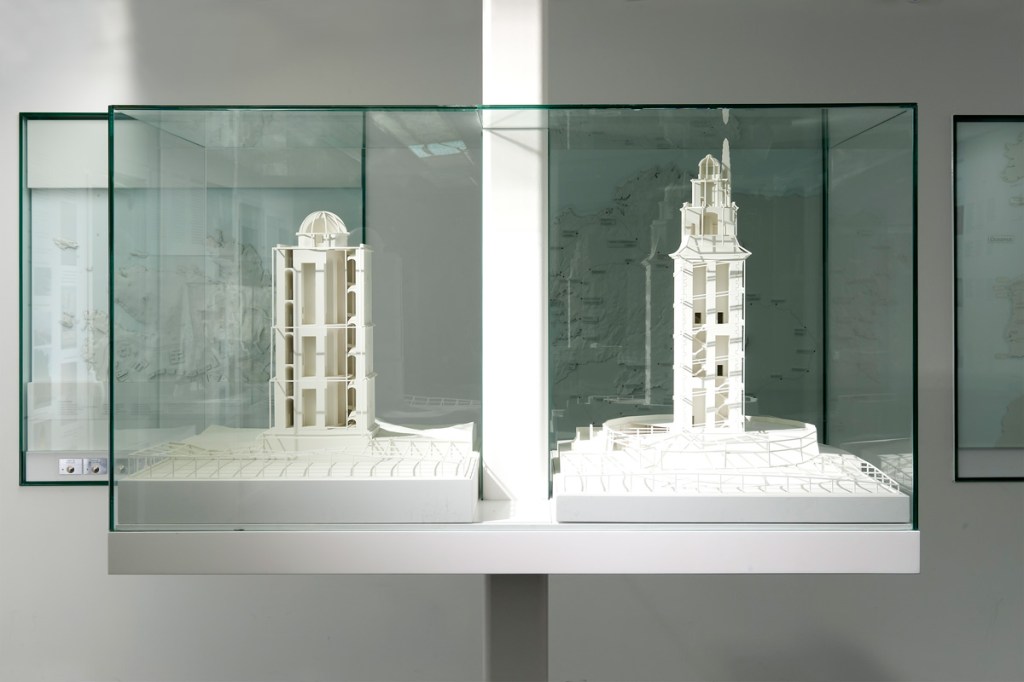
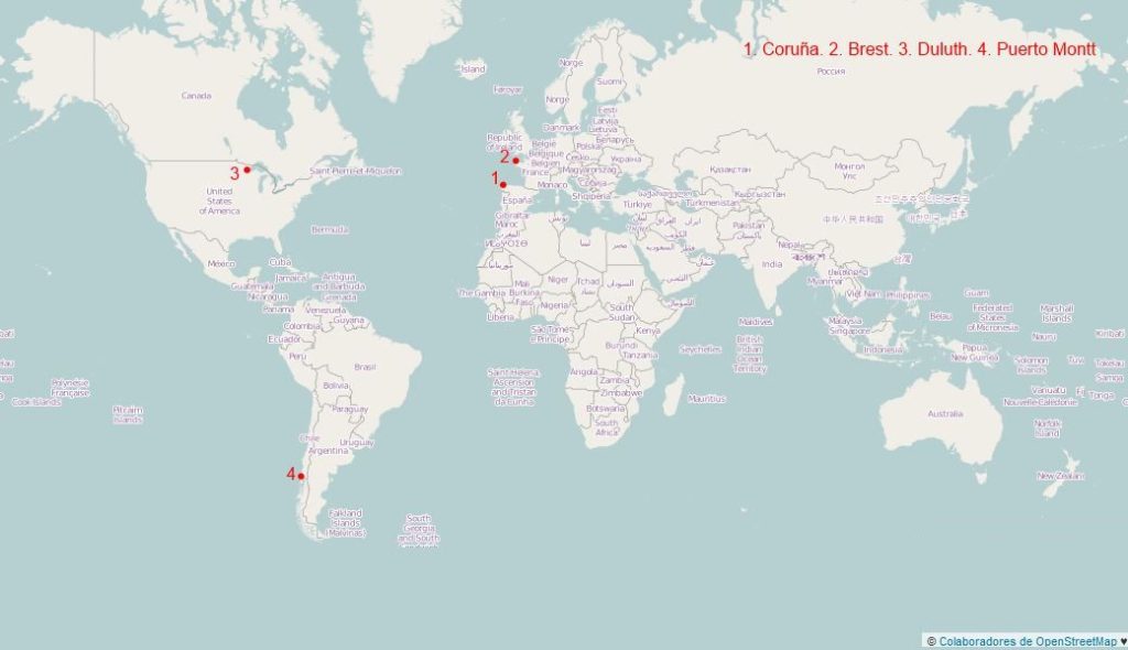
Far away ports (4) Histories. Towers, submarines, beavers, salmons…

La Coruña port existed in roman times. The Hercules Tower, a roman lighthouse which is thought to have been built during the first century AC, shows the relevance of the area during that time. The relevant port of the region was present Betanzos (Brigantium), as its ria was less silted and ships were smaller. During the Middle Ages the city becomes more relevant, and the opening of the American trade after the end of the monopoly of Seville and Cadix helps. Around the mid XXth century the port occupies most of the southern bay, protected by the peninsula; this is the last vision of Spain for thousands of Galicians migrating to America. During the 1960’s a large jetty is built to enlarge he port, and a new oil refining plant gives relevance to liquid bulks. This also leads to several tanker accidents that pollute the air and the ocean. The transition to democracy with the death of Franco brings regional devolution and the loss of the regional capital to Santiago, with the transfer of many public jobs. During the last decade a new port has been built, west of the historic bay, in part to reduce risks (oil wharfs are linked to the refining plant by a pipeline near homes), but the location is clearly into the metro area. The presence in that metro area of the headquarters of Inditex, the textile group owning Zara, helps to a certain degree to weather the current economic crisis.

Brest

Brest is first mentioned in history as a roman encampment at the end of the IIIrd century AC. The estuary of the river Penfeld made for a good natural harbour for the ships of the age. In 1593 Henri IV incorporates Brest as city, and in 1631 Richelieu establishes an arsenal on the Penfeld’s banks. The city plays a relevant role for the fleets helping the United States in their Independence War. The XIXth century starts under the British naval blockade, hurting the port; this changes under the second empire, with a wider sea trade, new rail lines and bridges over the Penfeld. Urban growth goes crosses the historic walls. Bigger ships make the need for a larger port, out of the Penfeld estuary, and new warfes are open on the large bay. During WW2 the port becomes a German Naval base and is bombed by the allies, which destroy a large portion of the city, later rebuilt. The creation of the Oceanic Strategic Force in 1972 leads to the creation of the new nuclear submarines base on Ile Longue, south of the bay. The reduction in military budgets hurts the city.

Duluth

Duluth receives its name from the first European explorer of the area, a XVIIth century French soldier which was called “Sieur du Luth”. The first known residents were the Anishinaabe tribe, which played a mediating role between the French and other Indian nations. Fur trade (especially beaver) was a relevant part of that early trade. In the mid XIXth century cooper mines, new locks allowing the arrival of large ships to lake Superior and plans for new rail linking the city to the Pacific (creating so a inter-ocean port) helped fuel the inception of the city. The port and the city grew exporting ore (mainly iron) and cereals. The crisis of the traditional heavy industry at the end of the XXth century has touched the city, but it is to a certain degree compensated by tourism and services to the metro area.

Puerto Montt in 1861.

Puerto Montt had some population prior to the arrival of the Spanish (southern Chile was never really incorporated to the Empire). Around the mid XIXth century German colonists started arriving to the area, and the city is incorporated in 1853. The rail line to Osorno starts operation in 1912. During the 1930 there is a substantial transformation of the waterfront, with new embankments, rail lines, a wharf and the dredging of the Tenglo channel. The city becomes in 1974 the capital of the Xth region (Los Lagos). Since 1985 the salmon production becomes important (and the plague problems for the species test the local economy), with other more traditional activities as agriculture, cattle or wood being also relevant. Tourism has become a relevant asset too.

Far away ports (3) Contraptions

Those that have never lived in a port city often have no idea on how variable their landscape is. A ship of a certain size can be longer and higher than many buildings, and its skyline can change with the arrival of sizeable volumes of colours that can be quite different from those of the buildings. However, this game is far from being reserved to ships.

Ports are, as cemeteries, areas in which architecture develops along particular lines. On the former, aesthetic rules can be taken far from what is allowed in the city of the living; in ports, what is utilitarian clearly takes control, as well for buildings as for any foreseeable contraption. There are outstanding port buildings, which have outstanding architectures, but most are rather limited in that sense, with multiple additions and improvements that are often without much architectural interest. When you focus on mobile contraptions, especially on freight ports, a world of vehicles, cranes and bridges opens and can easily become surprising.

The new crane (left) and the former, still in use model

The new crane (left) and the former, still in use model

Some days ago, walking by the port of La Coruña, I saw one of the new cranes in motion. Just a few decades ago the former, wood-cabin cranes were substituted by new, higher, steel ones, that as the former moved along railroad tracks. About a decade ago new cranes, a bit higher, moving on tires, were introduced. Seeing one such machine when they go from one wharf to another, moving very slow, is not without reminding the motion picture “Despicable me” and Gru’s car: high, with a permanent air of instability, and in fact seeming a toy… but for its overwhelming weight.

The dome on the left protects some solid bulks from the wind

The dome on the left protects some solid bulks from the wind

On the other side, the machinery for solid bulk, which sometimes can create allergic outbreaks if dispersed through the air, has a clear urban presence.

The Aerial Lift Bridge

The Aerial Lift Bridge

When ports are on busy circulation corridors, the need for bridges appears, and so that for complex solutions. In Duluth the Aerial Lift Bridge is one of the city icons. It was built to grant access to the Minnesota Point peninsula after the opening of a navigation channel through its base. The first years it was a transporter bridge, to be later transformed in the current car bridge with a vertical motion platform that adapts to the air draft of passing ships. Besides, as in many ports in this area of the great lakes, where iron ore is one of the most common bulk freights, the contraptions that allow the transfer of the load from trains to ships are simply impressive (something that can be well perceived on this video about a different port in Michigan http://www.youtube.com/watch?v=rzWwTOt39Es&list=PL7eOOJxsVrlgY0de0Osk7DTF8l2r9ksOb&feature=share&index=3). Such wharfs can only be seen (but not in active) in zones of Spain like Huelva or Almería.

Brest also has a moving bridge at Recouvrance, with a more contemporary structure. It is the main French port for naval repair, so it is common to see many large ships; as a relevant naval station, there are also many other “toys”, but not always visible.

View of Puerto Montt, as seen in the website of the Port Authority (empormontt.cl)

In Puerto Montt the port has less such contraptions; but you can see the Andean volcanoes on the background (something the other three ports can hardly compete with…)

Far away ports (2) Landscape and climate

The landscape of these four cities is marked by the irregular coastline, elevation, geology and vegetation.

Brest sits on top of a coastal cliff some 40 m high which overlooks the bay, with the Penfeld valley (the initial port) as its western limit. There are just a few zones around with heights over 60 m; the coast is marked by cliffs, but not by mountains or characteristic hill profiles. Ravines create valleys that are significant in this landscape.

Duluth is the meeting point for the northern Lake Superior hills and the plains to the south, as well along the Saint Louis river estuary. The city site is on a complex land, with steep slopes of volcanic genesis, something that has not helped street and building construction. The elevation difference from lakeshore to the highest points some 2 km inland is close to 200 m, and has contributed to a rich scenic context, attracting tourists since the 1880s. Ravins flowing into the lake have become natural limits between city zones. A sandbar at the mouth of the Saint Louis river estuary protects the harbour. The city has colonized the lakeshores and the estuary, as well as the hinterland.

La Coruña is on the western edge of the Artabrian gulf, a set of bights that reaches Ferrol to the North. It is a series of limited height hills, but on the areas neighboring the open seas, as on Monte de San Pedro. The city appeared on the eastern point of a peninsula united to the mainland by a narrow sandbar; during the XXth century the city has overflowed the plain areas to go uphill to the south and on the northern parts of the original peninsula. There is an inlet on each side of the peninsula, and the harbour is on the eastern one.

Puerto Montt municipality has some areas to the east with elevations well over 1.000 m, but the city itself is on much lower ground. The port sits on a rather benign slope, that is interrupted by a relevant cliff that gets up to the 100 m contour line. This allows for scenic vistas over the Seno de Roncagua, the large bay which extends to the south the Chilean central valley and separates the shores of the Andes from Chiloé Island. The harbour is on the channel between the mainland and Tenglo island.

The climate of these four cities is quite similar during their summers (Puerto Montt is on the southern hemisphere) ; you hardly get beyond 25 ºC, and rain is rather high. Only Duluth sees snow and freezing cold for several weeks on a row, so it has created a Skyways network.

Far away ports (1) A sample

La Coruña, Brest, Puerto Montt and Duluth: four mid-sized cities (metro populations between 200.000 and 400.000) that are often described as ports, that are rather far from the central areas of their countries. January will be in this blog the month of the far away ports, into the mid-sized cities series.

La Coruña is a relevant port and the hub for a relevant metro area that structures the Galician atlantic axis. Brest is the most populated city in western Britanny and a strategic port that has paid for this situation. Puerto Montt is the gate to the Chilean Patagonia, and Duluth is the end of the American Great Lakes and the coldest of these four cities; as for Duluth, even if it is somehow central when related to the 48 coterminous states, this only reminds that geography has an added complexity.

No doubt, these are diverse landscapes and conditions, but with common features: complex coastlines, rocky and hilly.

Happy Christmas Eve!

caleidoario2

Happy Christmas Eve! here we have two small objects designed by my sister, with a trilingual 2014 calendar; if there are kids around, they will probably love it. You will need scisors, glue and a bit of patience. The best option is to print each of the images, or just the one you prefer, either scenes from the Spanish city of La Coruña (file calido1) or the cute animals (file calido2) in an A3 (twice the letter format, for our US friends), using the pdf files from the precedent links. A4 (or letter) would probably be to small for most fingers.

WP_001513 WP_001514 WP_001511

A cute 3d object results.
caleidoario