Chile

Biblio (104) A book on the Chile National Urban Planning Award

Premio Nacional de Urbanismo Chile

I’m fully aware I’ve just written about this same subject just a few days ago; here it is about a monograph on the recipients of the award since the first edition. As I mentioned, this award has been clearly irregular along time. An award first attributed in Chile in 1971 and kept in hold until 1996 is as if it was first attributed in England in 1978 to have a second edition in 1998; sometimes the debate about ideas is transposed to the political landscape in such a way as to make some matters irrelevant for a time.

I have no reason to doubt of the interest for the Chilean nation of the works of each award recipient, but I will focus on the highlighted works; the first time it was a social housing project, the second one a metropolitan and infrastructure planning experience, and the following ones integrate increasingly sustainable development and public participation.

On awards (4) Chile National Urbanism Award

borde costero chile

In 1971 the Housing and Urbanism Ministry of Chile established the National Urbanism Award; since 1996 the Colegio de Arquitectos (the professional board of Chilean architects) is also part of the organisation. The Award must recognize architects and other professionals that have shown excellence, creativity and substantial contributions to improve the quality of life in the cities of the country.

Up until now it has not followed a regular schedule, with six awards since 1971. The winner in 2014 has been Sergio Baeriswyl Rada, an architect who has worked in the Bio Bio region. A public servant at the city of Conception (224.000 residents) since 1994, he has directed its Plan Regulador, which was innovative in using a public participation strategy and a corridor structure. He has been recently involved in the regeneration of the Bio Bio seashore after the 2010 earthquake and tsunami.

Beyond the personal award, that I assume is justified, I will focus on the plans. I have never visited Chile, so what I say comes from an analysis of secondary sources. The Plan Regulador de Concepción defines (according to its bylaws as published in the municipal website, including amendments up to September 2009) areas which are subject to natural and anthropic risks; on these areas any project shall be preceded by a risk assessment, but there is no outright ban on building. This may seem strange to a layman, but it happens in many countries, as sometimes the safe areas are not in a convenient place; just think of Paris, when there are relevant underground quarries that are no longer exploited but create risk situations, or most of England, where floods are common on urban areas. In spite of that, in Europe there is an evolution towards a total ban on building on risk areas whenever feasible, as for instance this is impossible in most of the Netherlands.

The plans for the coastal populations, prepared after the tsunami, define areas in which homes and public facilities are forbidden, and it seems a good measure.

Biblio (93) National Urban Development Policy, Chile

biblio 93- politica urbana chile

This year the new Chilean national policy on urban development has been enacted. As it has been approved under the now former president Sebastian Piñera, its effective application remains to be seen, but it is anyway an interesting document to understand the country.

As in many Latin American countries, since the 1980s there has been a relevant economic growth with effects for all the population, even if Chile still has clear inequalities. Current urban problems come largely from urban management decisions taken in a rush to solve urgent issues, without enough reflection, something that can hardly be confined to that country. There are positive signs in terms of sustainable development, as the growing share of multilevel housing and the contention of sprawl. But environmental protection and heritage conservation are in trouble, and housing remains, despite all the clear improvements, a challenge, with a deficit of about half a million dwellings in a country of some 17 million residents. Let’s not forget that in 2015 the goal of 100% sewage waters treatment could be achieved, not a small feat for any country.

You can choose the Spanish language version or the English language version

Far away ports (9) The Plan Regulador Intercomunal at Puerto Montt- Puerto Varas

supramunicipal puerto montt

The plan – published draft

The plan (started in 2009, under environmental scrutiny as of 2013) defines a land use model for a 860 sq km zone including part of the territory of five municipalities. It encompasses two coastal areas (the southern shore of the Llanquihue lake and the seashore around Puerto Montt), as well as the main north-south Chilean throughfare, the Panamerican Highway, as it crosses the area. The aerial images show an interesting landscape in which this road, stretching along a plain, seems to attract varied uses.

The aim is to set a frame for urban growth, preventing sprawling growth around the lakeshore, conserving farmland and forests, and ensuring an urban model that respects the environmental assets of the region while providing services to citizens and prevention against natural risks. But maps seems to show a substantial growth area along the lakeshore, with some caution areas concerning natural risks. To be seen in the final plan… Anyway, the port is an economic asset, but what is transforming the land (as nearly everywhere) is the car…

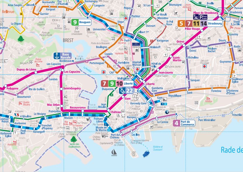
Far away ports (5) Transit maps

Ports have a central meaning as nodes in a network of maritime transportation; a ship captain can only get to the right harbour if provided a good navigation chart. So it is interesting to see how the residents of these port cities are told how to go from one place to another by public transit (mainly bus in cities this size).

This somehow brings to the mind the work of Kevin Lynch on the image of the city, as well as how citizens perceive it. Sure, architects like global maps in which the whole network can be seen, but these are not always easy to understand for lay people, and besides their design is not always clear.

La Coruña has a lines map quite complex. It is a peninsula with a narrow isthmus which causes a heavy density of lines in certain areas, so it is not that easy for some to understand how to go from A to B. Bus stops have a simplified version of that network; some people complain that the map is hard to read in dense zones. The transit company’s website shows simply a list of stops along each line, and a link to google for maps showing which streets the bus takes.

Líneas transporte urbano puerto montt (www.loslagos.transporteinforma.cl)

I have found no clear, structured website about urban transit in Puerto Montt, but rather (and it seems quite usual in Chile) a central Government site that explains, by province, the transit networks by classes, including the municipal scale.

parte bus

Brest has the most sophisticated public transit system of these four cities, with supra-municipal scale and a tram line. There is a real network map, quite clear, which reproduces the map of the territory without deformations; besides, line maps are also based on the geographical map. There is also an interactive map.

DTA Routes

Even if this may come as a surprise to many given its quite peripheral location in the US and its sprawl, Duluth also has a public transit system. There is a map of the whole network, and the line maps are, as many similar things in the US (just think of the zoning map in NYC) utterly simple, but efficient. The street grid is reproduced under the line layout without deformations, for each line.

Overall, despite the role of the ports in the economies of these cities, transit networks show overall that there is a more complex reality (being otherwise clear that this minute analysis is just considering line layouts, excluding such things as schedules or fares).

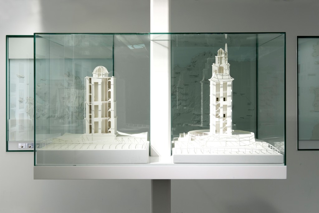
Far away ports (4) Histories. Towers, submarines, beavers, salmons…

La Coruña port existed in roman times. The Hercules Tower, a roman lighthouse which is thought to have been built during the first century AC, shows the relevance of the area during that time. The relevant port of the region was present Betanzos (Brigantium), as its ria was less silted and ships were smaller. During the Middle Ages the city becomes more relevant, and the opening of the American trade after the end of the monopoly of Seville and Cadix helps. Around the mid XXth century the port occupies most of the southern bay, protected by the peninsula; this is the last vision of Spain for thousands of Galicians migrating to America. During the 1960’s a large jetty is built to enlarge he port, and a new oil refining plant gives relevance to liquid bulks. This also leads to several tanker accidents that pollute the air and the ocean. The transition to democracy with the death of Franco brings regional devolution and the loss of the regional capital to Santiago, with the transfer of many public jobs. During the last decade a new port has been built, west of the historic bay, in part to reduce risks (oil wharfs are linked to the refining plant by a pipeline near homes), but the location is clearly into the metro area. The presence in that metro area of the headquarters of Inditex, the textile group owning Zara, helps to a certain degree to weather the current economic crisis.

Brest

Brest is first mentioned in history as a roman encampment at the end of the IIIrd century AC. The estuary of the river Penfeld made for a good natural harbour for the ships of the age. In 1593 Henri IV incorporates Brest as city, and in 1631 Richelieu establishes an arsenal on the Penfeld’s banks. The city plays a relevant role for the fleets helping the United States in their Independence War. The XIXth century starts under the British naval blockade, hurting the port; this changes under the second empire, with a wider sea trade, new rail lines and bridges over the Penfeld. Urban growth goes crosses the historic walls. Bigger ships make the need for a larger port, out of the Penfeld estuary, and new warfes are open on the large bay. During WW2 the port becomes a German Naval base and is bombed by the allies, which destroy a large portion of the city, later rebuilt. The creation of the Oceanic Strategic Force in 1972 leads to the creation of the new nuclear submarines base on Ile Longue, south of the bay. The reduction in military budgets hurts the city.

Duluth

Duluth receives its name from the first European explorer of the area, a XVIIth century French soldier which was called “Sieur du Luth”. The first known residents were the Anishinaabe tribe, which played a mediating role between the French and other Indian nations. Fur trade (especially beaver) was a relevant part of that early trade. In the mid XIXth century cooper mines, new locks allowing the arrival of large ships to lake Superior and plans for new rail linking the city to the Pacific (creating so a inter-ocean port) helped fuel the inception of the city. The port and the city grew exporting ore (mainly iron) and cereals. The crisis of the traditional heavy industry at the end of the XXth century has touched the city, but it is to a certain degree compensated by tourism and services to the metro area.

Puerto Montt in 1861.

Puerto Montt had some population prior to the arrival of the Spanish (southern Chile was never really incorporated to the Empire). Around the mid XIXth century German colonists started arriving to the area, and the city is incorporated in 1853. The rail line to Osorno starts operation in 1912. During the 1930 there is a substantial transformation of the waterfront, with new embankments, rail lines, a wharf and the dredging of the Tenglo channel. The city becomes in 1974 the capital of the Xth region (Los Lagos). Since 1985 the salmon production becomes important (and the plague problems for the species test the local economy), with other more traditional activities as agriculture, cattle or wood being also relevant. Tourism has become a relevant asset too.

Far away ports (3) Contraptions

Those that have never lived in a port city often have no idea on how variable their landscape is. A ship of a certain size can be longer and higher than many buildings, and its skyline can change with the arrival of sizeable volumes of colours that can be quite different from those of the buildings. However, this game is far from being reserved to ships.

Ports are, as cemeteries, areas in which architecture develops along particular lines. On the former, aesthetic rules can be taken far from what is allowed in the city of the living; in ports, what is utilitarian clearly takes control, as well for buildings as for any foreseeable contraption. There are outstanding port buildings, which have outstanding architectures, but most are rather limited in that sense, with multiple additions and improvements that are often without much architectural interest. When you focus on mobile contraptions, especially on freight ports, a world of vehicles, cranes and bridges opens and can easily become surprising.

The new crane (left) and the former, still in use model

The new crane (left) and the former, still in use model

Some days ago, walking by the port of La Coruña, I saw one of the new cranes in motion. Just a few decades ago the former, wood-cabin cranes were substituted by new, higher, steel ones, that as the former moved along railroad tracks. About a decade ago new cranes, a bit higher, moving on tires, were introduced. Seeing one such machine when they go from one wharf to another, moving very slow, is not without reminding the motion picture “Despicable me” and Gru’s car: high, with a permanent air of instability, and in fact seeming a toy… but for its overwhelming weight.

The dome on the left protects some solid bulks from the wind

The dome on the left protects some solid bulks from the wind

On the other side, the machinery for solid bulk, which sometimes can create allergic outbreaks if dispersed through the air, has a clear urban presence.

The Aerial Lift Bridge

The Aerial Lift Bridge

When ports are on busy circulation corridors, the need for bridges appears, and so that for complex solutions. In Duluth the Aerial Lift Bridge is one of the city icons. It was built to grant access to the Minnesota Point peninsula after the opening of a navigation channel through its base. The first years it was a transporter bridge, to be later transformed in the current car bridge with a vertical motion platform that adapts to the air draft of passing ships. Besides, as in many ports in this area of the great lakes, where iron ore is one of the most common bulk freights, the contraptions that allow the transfer of the load from trains to ships are simply impressive (something that can be well perceived on this video about a different port in Michigan http://www.youtube.com/watch?v=rzWwTOt39Es&list=PL7eOOJxsVrlgY0de0Osk7DTF8l2r9ksOb&feature=share&index=3). Such wharfs can only be seen (but not in active) in zones of Spain like Huelva or Almería.

Brest also has a moving bridge at Recouvrance, with a more contemporary structure. It is the main French port for naval repair, so it is common to see many large ships; as a relevant naval station, there are also many other “toys”, but not always visible.

View of Puerto Montt, as seen in the website of the Port Authority (empormontt.cl)

In Puerto Montt the port has less such contraptions; but you can see the Andean volcanoes on the background (something the other three ports can hardly compete with…)

Far away ports (2) Landscape and climate

The landscape of these four cities is marked by the irregular coastline, elevation, geology and vegetation.

Brest sits on top of a coastal cliff some 40 m high which overlooks the bay, with the Penfeld valley (the initial port) as its western limit. There are just a few zones around with heights over 60 m; the coast is marked by cliffs, but not by mountains or characteristic hill profiles. Ravines create valleys that are significant in this landscape.

Duluth is the meeting point for the northern Lake Superior hills and the plains to the south, as well along the Saint Louis river estuary. The city site is on a complex land, with steep slopes of volcanic genesis, something that has not helped street and building construction. The elevation difference from lakeshore to the highest points some 2 km inland is close to 200 m, and has contributed to a rich scenic context, attracting tourists since the 1880s. Ravins flowing into the lake have become natural limits between city zones. A sandbar at the mouth of the Saint Louis river estuary protects the harbour. The city has colonized the lakeshores and the estuary, as well as the hinterland.

La Coruña is on the western edge of the Artabrian gulf, a set of bights that reaches Ferrol to the North. It is a series of limited height hills, but on the areas neighboring the open seas, as on Monte de San Pedro. The city appeared on the eastern point of a peninsula united to the mainland by a narrow sandbar; during the XXth century the city has overflowed the plain areas to go uphill to the south and on the northern parts of the original peninsula. There is an inlet on each side of the peninsula, and the harbour is on the eastern one.

Puerto Montt municipality has some areas to the east with elevations well over 1.000 m, but the city itself is on much lower ground. The port sits on a rather benign slope, that is interrupted by a relevant cliff that gets up to the 100 m contour line. This allows for scenic vistas over the Seno de Roncagua, the large bay which extends to the south the Chilean central valley and separates the shores of the Andes from Chiloé Island. The harbour is on the channel between the mainland and Tenglo island.

The climate of these four cities is quite similar during their summers (Puerto Montt is on the southern hemisphere) ; you hardly get beyond 25 ºC, and rain is rather high. Only Duluth sees snow and freezing cold for several weeks on a row, so it has created a Skyways network.

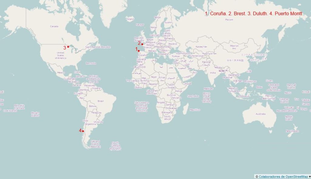
Far away ports (1) A sample

La Coruña, Brest, Puerto Montt and Duluth: four mid-sized cities (metro populations between 200.000 and 400.000) that are often described as ports, that are rather far from the central areas of their countries. January will be in this blog the month of the far away ports, into the mid-sized cities series.

La Coruña is a relevant port and the hub for a relevant metro area that structures the Galician atlantic axis. Brest is the most populated city in western Britanny and a strategic port that has paid for this situation. Puerto Montt is the gate to the Chilean Patagonia, and Duluth is the end of the American Great Lakes and the coldest of these four cities; as for Duluth, even if it is somehow central when related to the 48 coterminous states, this only reminds that geography has an added complexity.

No doubt, these are diverse landscapes and conditions, but with common features: complex coastlines, rocky and hilly.

Housing (2) Progressive housing in Chile

A project by Elemental in Chile. On the upper image, the housing units as delivered to dwellers; for each "L" there is a ground floor home and a two storey home on top. The lower image shows the buildings after some time.

A project by Elemental in Chile. On the upper image, the housing units as delivered to dwellers; for each “L” there is a ground floor home and a two storey home on top. The lower image shows the buildings after some time.

Up until the arrival of the XXth century and the housing policies, it was common to see people build their own homes, especially in villages and urban areas in which individual housing was common; homes were extended according to the household economy.

Even if this is still possible in some areas, in Europe now the usual is to see housing as a finished product to which you come to live without having been involved in the works, and without plans for a future extension, and that includes social housing (even if in somehow recent moments there were still in parts of Spain experiences of social housing involving work by future dwellers). In fact, building codes and quality demands make quite difficult the option.

How to organize a housing policy in countries with scarce public resources, low income populations and pressing needs? In Latin America it is common to see “progressive housing” programs and the Chilean has a 50 years experience. The public administration (or the future dwellers in some cases) builds a reduced part of the building, with the load bearing main elements and the most complex systems (water, sewage, energy), and later each family extends the building according to its economic capacity. It is a far cry from the idea of complete formal control of the urban image, there are many issues that are far from well solved, but this has allowed a sizeable group of households to own a place to call their own. The programs have been linked in many countries to the large land property regularization programs.

The practice Elemental (www.elementalchile.cl), led by Alejandro Aravena, has recent works that illustrate well this principle.