Coruña

Far away ports (8) The port is dead, long live the port

puertos int-ext

Think of a complex coastline, which is under the regular impact of strong storms that even in the case of large oil tankers can lead to relatively high shipwreck events. One day comes the tanker whose wreck becomes, for various reasons of diverse coherence, a social threshold, a wreck too many. This happened in Galicia (north-western Spain) in 2002 with the Prestige tanker. As a result, the Spanish government (with powers over large ports) decides to create in La Coruña (b on the upper image) and Ferrol (d) two new large external harbours (a and c). The rationale is to take hazardous traffics off the city centres. Creating new infrastructures is rather common, but here the operation brings to mind what to do with urban core quays. Bilbao managed to conduct such an operation some 10 years ago around the Guggenheim museum.

The new General Plan of La Coruña. Urban extension land is red. The new harbor is on a different municipality.

The new General Plan of La Coruña. Urban extension land is red. The new harbor is on a different municipality.

The new General Plan of La Coruña defines a new residential area over much of what now are quays. The municipality is rather small, and quite occupied by urban areas, so it is a growth option. This will transform what is now an urban core harbour, and seems rather an industrial area, in a different thing, raising questions about how the soul of the city will change. But it also raises questions on how long this will take in a crisis context.

In the middle of this there is a large water surface.

In the middle of this there is a large water surface.

The port transformation proposal

The port transformation proposal


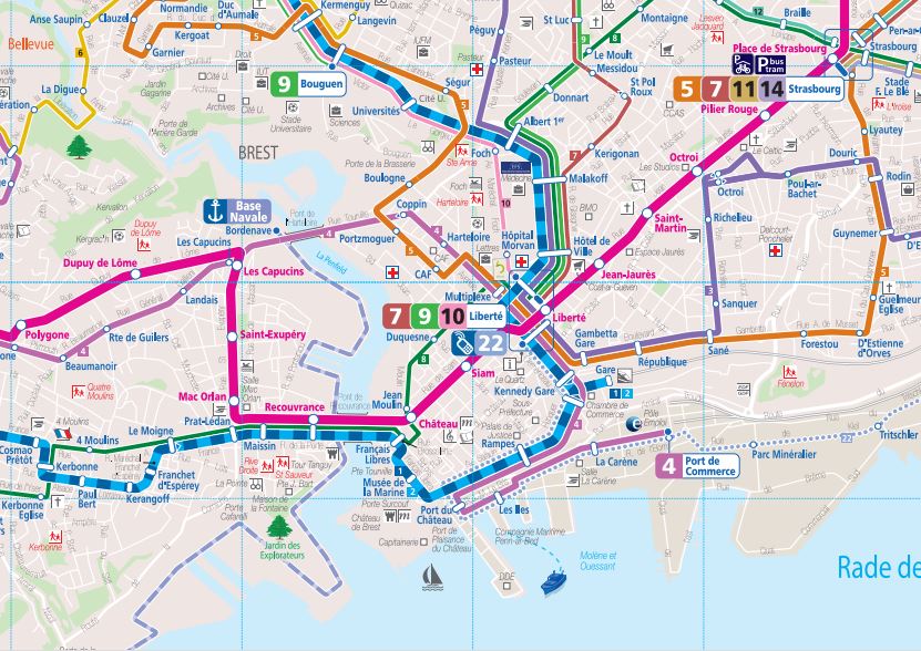
Far away ports (5) Transit maps

Ports have a central meaning as nodes in a network of maritime transportation; a ship captain can only get to the right harbour if provided a good navigation chart. So it is interesting to see how the residents of these port cities are told how to go from one place to another by public transit (mainly bus in cities this size).

This somehow brings to the mind the work of Kevin Lynch on the image of the city, as well as how citizens perceive it. Sure, architects like global maps in which the whole network can be seen, but these are not always easy to understand for lay people, and besides their design is not always clear.

La Coruña has a lines map quite complex. It is a peninsula with a narrow isthmus which causes a heavy density of lines in certain areas, so it is not that easy for some to understand how to go from A to B. Bus stops have a simplified version of that network; some people complain that the map is hard to read in dense zones. The transit company’s website shows simply a list of stops along each line, and a link to google for maps showing which streets the bus takes.

Líneas transporte urbano puerto montt (www.loslagos.transporteinforma.cl)

I have found no clear, structured website about urban transit in Puerto Montt, but rather (and it seems quite usual in Chile) a central Government site that explains, by province, the transit networks by classes, including the municipal scale.

parte bus

Brest has the most sophisticated public transit system of these four cities, with supra-municipal scale and a tram line. There is a real network map, quite clear, which reproduces the map of the territory without deformations; besides, line maps are also based on the geographical map. There is also an interactive map.

DTA Routes

Even if this may come as a surprise to many given its quite peripheral location in the US and its sprawl, Duluth also has a public transit system. There is a map of the whole network, and the line maps are, as many similar things in the US (just think of the zoning map in NYC) utterly simple, but efficient. The street grid is reproduced under the line layout without deformations, for each line.

Overall, despite the role of the ports in the economies of these cities, transit networks show overall that there is a more complex reality (being otherwise clear that this minute analysis is just considering line layouts, excluding such things as schedules or fares).

Have a nice 2014

La Coruña, Spain

La Coruña, Spain

A new year. 365 days to think and talk. In Spain some find signs that macroeconomics go better, and some find that population is not seeing the results (both things could eventually be happening alongside); those that think that the environment is getting better as vegetation is growing on what was to be a series of buildings, and those that say that it is getting increasingly fragile. There are probably places in which things go better, or worse, without getting out of this planet. Meanwhile, other things happen in the world, and not being as serious is far from meaning that they are uninteresting. Let us continue with the visit, paying attention to subjects as mid-sized cities, often more interesting than megalopolis. Thanks for joining the conversation.

Under the rug (2) La Coruña

Here is the coastline I know best. Bathymetric data is still that of the General Bathymetric Chart of the Oceans , by the British Oceanographic Data Center,  with depth contours in meters. Contour zero comes from a generalization of the digital elevation model, and it is into the current sea when compared to the real coastline, so I render it to show the precision level of the data source, which is enough given the visible scale.

bajocoruña

The Galician rias are considered in Spain an example of the way the sea and the land can relate. The sea, but what would happen if the sea were to disappear (an unlikely event) mark the landscape?. Here a substantial part of the landscape that can be seen east of Monte de San Pedro, a belvedere over La Coruña (A on map) would be at a depth lower than Hercules Tower, the Roman lighthouse of the city, inscribed in the UNESCO world heritage list.

bajocoruña-torre

The elevation of the tower over the current sea level is already substantially higher than the surrounding depths. On the image, you can see an approximate rendering of depth 25 m contour, as well as the height of the tower. The landscape of the area would change if the sea receded, but not just due to the absence of water, that unifies the image, as there would also be shipwrecks, rubbish and other signs of the human presence in the city over the centuries.

Hypothesis 200 m (3)

Lisboa

Most of the coastal metro areas would simply dissapear under water (upper image, Lisbon). For some, the new coastline would be just a handful of islands with no links, but for others (lower image, the Artabrian gulf between La Coruña and Ferrol) the new shore would be even a bit simpler than the existing one. The summits of the coastal hills would remain, not being necesarily the most interesting thing.

LC

Sister cities (2) Land’s ends

The end of known lands (for someone…) was in these cities. When Julius Caesar arrived at Portus Magnus Artabrorum (Coruña) in the first century BC, other romans settled Gesocribate (Brest) in the third century, or Nikolai Muraviov first arrived in present-day Vladivostok in 1859, there was surely a certain idea of being far, far way… even today these cities are good natural harbors at the end of main communication lines.

These are hilly cities, with interesting landscapes of complex bays, sparkled with beaches, docks and diverse military compounds; Ferrol, Ile Longue and the Vladivsotok Arsenal are key bases for the navies of the three countries.

In Vladivostok the border condition is a part of its caracther, few kilometers away from the Chinese and Korean borders. Until the Aigun treaty and the arrival of Muraviov just some 150 years ago, the Russian Maritime Provinces were a sparsely populated area under the Chinese orbit.

In Brest the destruction of the city during WWII led to a postwar reconstruction that included the destruction of the city walls and extensive grading and eathworks that altered the traditional relation of the cityscape with the sea.

In La Coruña the urban duality with Ferrol, at the other end of the rias altas arc, configures a long metropolitan area, which is more complex in territorial terms than the other two cases, in which the central city is more relevant.

Real street in La Coruña

real-300m

Real street in La Coruña (Galicia, Spain) is one of the most relevant in the historical core. Some 300 m long and 7 m wide, it was historically an inner road as related to the seashore, today at a greater distance due to landfill. The urban patter is relatively regular, although not homogeneous in geometrical termes: the axis of the street is not entirely straight, but the end can be seen from the beginning.

The street was historically a retail core for the city; the metropolitan expansion, peripheral malls and economic crisis have since eroded that role, today largely diluted.

The architectural uniformity is rather maintained in the central section, but there have been relevant changes to the west (A). The paving, made of large granite slabs (that can give you “downside up rain” on rainy days if they move…) is still there. It is a pedestrian street, but for deliveries to retail, as many of the surrounding streets, not only by regulations, but also due to their dimension (and the lack of garages in such narrow lots…)

Real-1 Real-2

Urban retail (10) Coruña – b

A bakery in the hyperdense city.

A bakery in the hyperdense city.

As I had already said some posts ago, the time allocated to the act of buying each good is a relevant figure. It is not only the time that you use, but also how often you do it. For a reason or another, you will not buy a wedding ring each month, or a car each quarter, or a paper notebook each week… This leads us to a relevant distinction among shops, according to the frequency by which you buy their goods: frequent buys (bakery, news agents, food in general) and non frequent buys (apparel, personal equipment, luxury, furniture…)

At least in Europe, and certainly in this dense city of La Coruña, this last category of unfrequent use shops is the key to retail centralities. You buy your bread on the way back home, but on saturday you flock to see the shops looking for that product you think long time about…

Jewelers

Jewelers

Jewelers are concentrated on the isthmus, and specially in Calle Real, the historical grand commercial street. Their pressence in the rest of the city is not a concentrated

Apparel shops

Apparel shops

Three hotspots appear for apparel stores: Calle real again, a more recent centrality in the ronda de Outeiro to the southwest (Calle Barcelona, an open commercial center around a pedestrianised street), and the densest spot in the El Corte Inglés department store and its surroundings.

Supermarkets

Supermarkets

Supermarkets are scatered along the city, but here only the largest ones appear.

Butchers

Butchers

Butchers are scatered following density. In the historical areas of the isthmus, they are less representative as they are often displaced by other retail uses.

Pharmacies

Pharmacies

Pharmacies are a higly regulated activity, location included. They are scatered across the city, as it corresponds to a frequent use item.

8lc-suplibrer

Bookshops

Bookshops include here also your neighborhood newsagent. Nevertheless, big bookshops in the central areas are apparent.