SDRIF

Biblio (64) SDRIF, at last…

The SDRIF (Schéma de Directeur de la Région d’Ile de France, regional planning for the Paris region) has finally been aproved by the region, and should be enacted by the French State Council before the end of the year. You can read about it on http://www.iau-idf.fr/debats-enjeux/le-schema-directeur-de-la-region-ile-de-france-sdrif.html

SDRIF 2012- Paris. Mobility


The mobility policies are among the “hard” elements in most of the Plan that can be compared to the SDRIF. It is a capital investment issue, that usually drains much of the funds allocated to the new territorial model (not having found a precise financial programme for SDRIF this is still hard to judge here), and the public actors are, at least in Europe, highly implicated. It is also a range of policies with direct impacts on territorial competitivity, but also on environment, due to the impact of linear infrastructure and greenhouse gas emissions.

Paul Delouvrier’s Schema Directeur from the 1960s introduced as mobility landmark the RER (regional express network of high frequency trains), as well as a Peripherique inner beltway that was already being built and the radial freeways, as well as the A-86 outter beltway proposal. 1994’s SDRIF included the Francilienne external beltway and improvements to RER, as well as the idea for a transversal public transit connection between suburbs.

2012’s project introduces as new ideas:

  • A more defined project for the transversal links between suburbs, mainly on the inner ones, with a 200 km Grand Paris Express automatic subway (today being debated, as the State should decide or not to allocate 1 billion euros to the project). It is the star investment, showing that Grand Paris is not just the theme for an architecture competition, but a defined plan.
  • Tram-train lines contributing to transversal links
  • Traffic calming on the Peripherique and the initial sections of the radial freeways, as well as a special treatment for metropolitan boulevads and avenues. Even if there are projects for some freeway links (for instance, Roissy Beltway), they are not the main issue. The multimodal use of the freeways, introducing high occupancy and transit reserved lanes (as on Madrid’s A6), is presented as the new normal. Traffic calming should also allow new uses in the current no-build zone around freeways, allowing bus stations and other facilities. It is one of the most relevant ideas of the SDRIF in environmental terms, as it would reduce greenhouse gas emissions

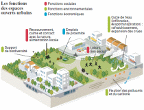
SDRIF 2012-Paris. Environment


Drawing a greenbelt can be the starting point for many dissapointments: as most of the time we do not work on a “virgin” territory, the belt will almost never be closed, and its shape will be not that clear at first sight. In the SDRIF as often in other parts of the world, there is a Greenbelt project that works with reality; woods around Paris are integrated, as well as regional natural parks, and the debate could be in the conectivity among these spaces. The role of rivers as ecological connectors is also relevant and integrated (even when the Seine banks are sometimes stockage areas for construction materials, it is a truth that nature prevails somehow…). Overall, SDRIF tries to ensure these continuities, in which farmland is also relevant, as much for landscape as for ecologic continuity.

Those open spaces are also used to limit urban growth, and this, combined with the aim to improve the quota of green space per habitant in the denser areas (a complex operation, as sometimes it involves new buildings to ensure a balance between the cost of the new parks and the new revenue), can contribute to improve the quality of life. These spaces must also integrate as much as possible flood plains, a relevant issue in a metropolitan area with large rivers.

SDRIF 2012-Paris. Housing


The estimated need of housing units to adress future demand for main houses is 1,5 million units by 2030, an average 70.000 units per year, which result from:

  • 38.000 units per year to adress the needs resulting from demographic growth, taking into acount a growth at the same speed as the overall french population taking into acount ageing population, residential behaviour and migrations.
  • 12.000 units per year to avoid a deeper deficit than today. This would allow a reduction in the household size as in the rest of the country, making easier for people to change their homes according to their needs.
  • 17.000 units per year to compensate demolition and other lost units in the old buildings
  • 3.000 units to maintain a vacancy rate similar to the present one, alredy the lowest in 40 years.

Overall, this building effort will compensate a regular decline in the housing production since the begining of the 1990s. It should allow to develop the offer of housing for students, old people, handicapped people, young workers, people in social risk, and nomads. Social housing would be developped to adress the current deficit.

Most of this process will correspond to private developers, depending so on the social and economic situation, and especially the acces to credit by both developer and citizens, the real purchasing power of households and the evolution of real estate prices.

SDRIF 2012 Paris- Roissy

Roissy- Charles de Gaulle airport, north of central Paris, is one of the main economic assets of the metropolitan area, and it is one of the project territories of the SDRIF 2012. Well linked to the metropolitan core and northern areas, it is less well connected to the west and east. The regional scale challenges are to find a balance between economic and residential development, to tackle the differences between a powerful economic scene and the social weaknesses, and to avoid a capacity overflow in roads.

Accesibility will be improved by high speed trains for the long haul travel, and by improvements in regional trains to be reinforced by the automatic subway “Grand Paris Express”. The noise plan for the airport limits land use locations. Improvements in employment beyond logistics and associated activities are a major goal, looking for a more diverse and qualified activity system.

Maintaining the large open spaces continuities north of the airport, as well for farming as for woods and natural systems, is also a major goal, as there is already a fragmented space due to transportation elements and urban elements.

The proposals by areas are:

  • To the north and east of the airport there should be an increased density and a development of public services in existing fillages. Le Mesnil- Amelot will have a Grand Paris Express station making it the gate to the metropolitan network for northern Ile de France and Picardie, and this will allow for an urban extension of the village.
  • To the west and south of the airport there is already a good accesibility by public transport, that will be improved, and many large metropolitan public facilities as the Exhibitions Park of Villepinte and the Sausset Park. The trend to locate large public facilities will be fostered.
  • The area around Le Bourget will be hotspot to develop aerospace industries and high tech
  • The Gonesse Triangle will be a strategic element due to its location halfway between Paris and the airport, and its economic and social developement needs in Val de France. 300 hectares at most should be urbanised, provided that they get public transit, and they will be limited by a regional project to preserve 400 hectares of farm land north of the triangle to ensure they are not fragmented.