The western edge of the M30 motorway in Madrid has been buried; but the eastern part remains on surface, and the way in which it has been contorted to integrate the new tunnels and engineering variances make for a complex geometry in some areas. And probably a missed opportunity in the greening of these “wasted” fringe spaces… (each one can have his say on what is wasted here)
urban freeways
Biblio (21). Shop changes in Paris
The Atelier Parisien d’Urbanisme (a city agency) is making a periodical census of retail establishments in the city since 2000, that allow not only to follow the progression in number but also in specialities and conditions. The last one was realised in april 2011 and published in 2000, with the collaboration of the Chamber of Commerce.
Paris had in 2011 some 84.000 establishments in ground floors, 61.232 being active shops. The number of shops has gone down some 900 since 2007, but this is also aproximately the number of shops that have been enlarged through anexations. The gross leasable area is estimated at some 4 million sq m, with a vacancy rate of 9,6% in 2011.
The study identifies 15 atractive nodes at city level, and a rich retail structure going from large department stores to small specality shops. One of the most interesting features is a graph of ups and downs by speciality, with, for instance, jewelers diminishing and motorbike sellers on the rise.
Having studied the urban implications of retail for some Spanish cities, I can tell that this is a good study on the isue, as it explains well a relevant issue: the continuous evolution of the retail sector, that requires flexibility in rules that, on the other side, must guarantee a good relation with other land uses, configuring a complex problem to be solved by good urban regulations.

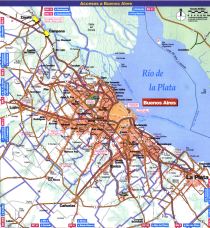
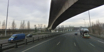
Urban freeways (7). Buenos Aires
The Metropolitan Area of Buenos Aires, with over 13 million people, is the second largest metropolitan area in the Spanish-speaking world, and, despite the crisis, one of the main economic hubs in Latin America.
According to “Desarrollo urbano y movilidad en América Latina” (urban development and mobility in Latin America), published by the Corporación Andina de Fomento in 2011, the mobility in that metropolitan area can be described by:
– Public transit have gone from 67% of total trips in 1972 to 40% in 2007
– A lack of structural improvements in public transit system for the last decades.
– Recent tender procedures for many projects that fail to materialize.
– Low speed for buses.
– A failure of the project to create dedicated bus lanes.
– Bad state of public transit stations.
– Inter administrative cooperation difficulties that prevent a unified planning of the transportation systems.
The idea of an urban highway network in Buenos Aires comes from the 1960s, as traffic congestion became a problem. In 1978 a call for proposals to build two toll urban highways was launched. They were opened in 1980 under a concession system, in a complex context with hiperinflation and political unstability (the end of dictature was near). So began a cycle of infrastructure creation that, due to economic hardship, was later passed from a private- public partnership to public ownership. Around 2000, the same history again, with the terrible 2001 crash of the national economy as a problem. The city has today 40 km of urban highways, some under toll systems.
THe social and economic dynamics of the country, that has seen its middle classes shrink dramatically in the last 40 years, shows to which extent public mobility policies of any kind require a certain stability to develop, as they depend on long-run credits.

Urban freeways (6). Santiago de Chile
Metropolitan Santiago de Chile has slightly more than 5 million people, configuring the main urban center of the country.
According to “Desarrollo urbano y movilidad en América Latina” (urban development and mobility in Latin America), published by the Corporación Andina de Fomento in 2011, the mobility in that metropolitan area can be described by:
– A sustained increase in revenues, with an unchanged social distribution pattern
– An urban expansion towards far away areas, as well for social housing as for high revenues
– Growing car ownership
– A consolidation of the subway as a transit mode
– Recent reforms in bus systems
De acuerdo con un artículo publicado en planeo.ieut.cl por Oscar Figueroa, durante la última década se ha puesto en marcha un sistema de 250 km de autopistas urbanas concesionadas a agentes privadas y sometidas a peaje. Cada una de las autopistas está sometida a un régimen de gestión específico. Los nudos de conexión con otros elementos de la red viaria presentan deficiencias (Costanera Norte con Autopista Central, Vespucio Sur con Autopista Central), y una inadecuada resolución de la sección transversal de la autovía en las zonas más pobres, creando problemas de permeabilidad transversal a los habitantes cercanos, que en ocasiones resultan en atropellos por falta de pasos a desnivel suficientes.
El sistema de peaje permite un aumento de capacidad, pero concentrando el coste en los usuarios directos, un paso positivo.

Urban freeways (5). Metropolitan Mexico
Mexico City’s metropolitan area, with slightly over 20 million people, is one of the most populated in the planet.
According to “Desarrollo urbano y movilidad en América Latina” (urban development and mobility in Latin America), published by the Corporación Andina de Fomento in 2011, the mobility in that metropolitan area can be described by:
– A spatial segregation between a central area with a mixed income range, a high income area to the west and a low income concentration to the east.
– A decreasing density during the last decades.
– Relevant investments in public transit, with a first suburban train line of 27 km from 2008, with low use statistics due to the ticket price and problems at links.
– An additional 250.000-300.000 cars hit the streets each year, with an exponential growth in motorbikes.
– Substantial quality deficits in public transit systems.
Many measures are being planned to try to tackle these problems, mainly on the public transit side. But some measures also involve freeways (according to Mexican government webs, 25% of investments).
The Periférico of México is a freeway with an average speed between 6 and 13 km per hour at peak moments. The proposed solution is a second level, using the same land already allocated to the freeway in the 1950s and 1960s. The second level includes a reserved lane for public transportation, and it is estimated that it will increase speeds and reduce lost labor hours and greenhouse gas emissions.
The future is hard to predict; official reports insist that the conditions of Mexico differ from those of European and North American cities, but only the future will tell whether the new infrastructure attracts new traffic. The introduction of toll systems for the second floor will probably be the diferential element.

Original image on http://www.flickr.com/photos/bdebaca/456080102/

Biblio 13.Mobility and urban freeways
The publication “Life and death of urban freeways” explains the evolution of a concept that many among us find today obsolete. It describes how public policies from the 1940s to the 1960s fueled the flight of the middle class to the suburbs, the role of many administrations aproving infrastructure projects as a solution to that problem, and the problems raised by the hughe economic, social and environmental costs of these urban freeways. The opposition movements, the new approaches to urban problems as those of Jane Jacobs in New York, and the way in which these approaches to mobility, today usually deemed as obsolete in “rich countries”, are applied by “emerging countries” are also analyzed, to finally show the demolition or integracion programmes for urban freeways in Portland, San Francisco, Milwaukee, Seul and Bogotá.
I think that what we usually forget and makes us unable to understand what happens in “emerging countries” going full-speed towards a car-dependant society is that the initial stages of car ownership surge in countries are often not subject to congestion, and the feeling of freedom a newly acquired car can bring, especially if there is no efficient public transportation system, is more a qualitative, emotional thing than a rational and quantitative one. The inertia of the images of the “rich countries”, with large freeways and cars, especially in a world dominated by tv, is also to be considered.
Latin America, an “emerging region” for the last years due to its high economic growth, shows, according to the publication “Desarrollo urbano y movilidad en América Latina”(urban development and mobility in Latin America),by the Corporación Andina de Fomento (a developpement bank):
– The economic growth in the last years, even if as unevenly distributed among citizens as traditionally in many cases, has brought a relevant increase in car ownership.
– Investment in urban highways is relevant, altough public transportation is being improved in many cities, and there are success stories as Curitiba in Brazil.
– Investments in mobility can contribuite to sustainable development in an effective way only when linked to urban and regional planning as to ensure an efficient system.

SDRIF 2012- Paris. Mobility
The mobility policies are among the “hard” elements in most of the Plan that can be compared to the SDRIF. It is a capital investment issue, that usually drains much of the funds allocated to the new territorial model (not having found a precise financial programme for SDRIF this is still hard to judge here), and the public actors are, at least in Europe, highly implicated. It is also a range of policies with direct impacts on territorial competitivity, but also on environment, due to the impact of linear infrastructure and greenhouse gas emissions.
Paul Delouvrier’s Schema Directeur from the 1960s introduced as mobility landmark the RER (regional express network of high frequency trains), as well as a Peripherique inner beltway that was already being built and the radial freeways, as well as the A-86 outter beltway proposal. 1994’s SDRIF included the Francilienne external beltway and improvements to RER, as well as the idea for a transversal public transit connection between suburbs.
2012’s project introduces as new ideas:
- A more defined project for the transversal links between suburbs, mainly on the inner ones, with a 200 km Grand Paris Express automatic subway (today being debated, as the State should decide or not to allocate 1 billion euros to the project). It is the star investment, showing that Grand Paris is not just the theme for an architecture competition, but a defined plan.
- Tram-train lines contributing to transversal links
- Traffic calming on the Peripherique and the initial sections of the radial freeways, as well as a special treatment for metropolitan boulevads and avenues. Even if there are projects for some freeway links (for instance, Roissy Beltway), they are not the main issue. The multimodal use of the freeways, introducing high occupancy and transit reserved lanes (as on Madrid’s A6), is presented as the new normal. Traffic calming should also allow new uses in the current no-build zone around freeways, allowing bus stations and other facilities. It is one of the most relevant ideas of the SDRIF in environmental terms, as it would reduce greenhouse gas emissions